

Hero image: Photo: South African Tourism from South Africa / Wikimedia Commons, CC BY 2.0
The Cederberg is a range of weathered sandstone about two and a half hours north of Cape Town — arches, cracked cliffs, clear pools, six thousand years of San and Khoi rock art, and some of the emptiest walking country in South Africa. It is also, in 2026, a landscape in the middle of a long recovery from two consecutive disasters, and that has to come before anything else on this page.
Almost every guide to the Cederberg you will find online was written before December 2025 and describes a place that does not currently exist. Roads that those guides treat as routine are closed. Campsites they recommend are shut. We have written this page from CapeNature’s own current notices, and we have said clearly where something could not be confirmed.
Access status checked 20 August 2026
Major parts of the Cederberg remain affected by fire and flood rehabilitation. Areas B and C are closed until further notice, the Algeria campsite is closed, and the direct road from Clanwilliam to Algeria is closed.
This is a temporary position in a landscape being repaired, not a permanent one. Check CapeNature current notices before travelling. CapeNature reservations and enquiries: 087 087 8250.
In this guide
- The Cederberg in brief
- Current access, and what is closed
- The wilderness area and who runs it
- Permits and what they cost
- Roads, and what vehicle you need
- Walking, and carrying water
- Wolfberg and the Maltese Cross
- Rock art
- Rocklands and bouldering
- Wupperthal
- The night sky
- Getting to the Cederberg
- When to come
- Where to stay in the Cederberg
- Nearby, and what to do next
- Practical notes
- Official sources
The Cederberg in brief
- Region — Cape West Coast, Western Cape. The mountains east of the N7 above Clanwilliam and Citrusdal.
- Managed by — CapeNature, for the Cederberg Wilderness Area; several key trailheads are on private farms.
- Why come — walking, rock art, bouldering, swimming holes, and a very dark night sky.
- Time needed — two nights minimum. It is a long way in on gravel, and a day trip wastes the drive.
- Right now — Area A and the Pakhuis Pass side are open. Areas B and C are closed. Plan around that, not around older guidebooks.
- Permits — required, always, for walking and for climbing. Tariffs quoted here expire 31 August 2026.
Current access, and what is closed
Two events, back to back. A wildfire ignited on 22 December 2025 on the Uitkyk Pass and burned roughly 53,000 hectares before it was contained on 5 January 2026. Cold fronts on 13 May 2026 then flooded the range, damaging roads, trails, offices and power infrastructure. CapeNature expects rehabilitation to continue into mid-2028.
The position below is taken from CapeNature access notice dated 30 June 2026, with the Algeria cottage reopening of 1 July 2026 applied. It is the single most important thing on this page.
| Area or facility | Status |
|---|---|
| Area A | Open — day and overnight hiking |
| Areas B and C | Closed until further notice |
| Kliphuis campsite, Pakhuis Pass | Open — reopened 25 May 2026. No firewood, because of the Shothole Borer Beetle |
| Algeria cottages | Open — reopened 1 July 2026, eight cottages |
| Algeria campsite | Closed — rehabilitation continuing |
| Bosherberge cottages (Uitkyk, Waenhuis, Prik se Werf, Peerboom, Sas se Werf) | Closed |
| Uitkyk Pass | Closed — road collapse |
| Jamaka to Algeria road, the direct Clanwilliam approach | Closed |
| Trails starting from Algeria, including the Waterfall and Van der Merwe routes | None operational |
| Mountain biking | Not recommended by CapeNature — erosion and unsafe conditions |
| Hiking permits | Issued at Kliphuis, about 65 km from Algeria |
Two practical consequences follow. First, Algeria is now reached only via Nieuwoudt’s Pass and the N7, not on the short road up from Clanwilliam. Second, if you are based at Algeria, the southern Cederberg — Stadsaal, Truitjieskraal, the Wolfberg and the Maltese Cross — is not sensibly reachable from there; CapeNature puts it at roughly a 400 km round trip via Citrusdal. Decide which side of the range you want before you book.
The wilderness area and who runs it
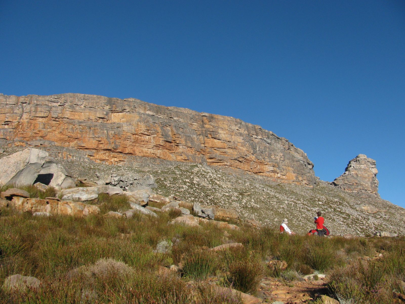
The Cederberg Wilderness Area is managed by CapeNature and was proclaimed a wilderness in 1973, which makes it one of the oldest formally protected wilderness areas in the country. CapeNature publishes two different figures for its size — 66,811 hectares on the reserve page and about 71,000 hectares in its brochure. We use the reserve-page figure and flag the discrepancy rather than picking whichever number sounds better. The adjoining Matjiesrivier Nature Reserve adds a further 12,800 hectares, and is where the Stadsaal caves are.
The wilderness forms part of the Cape Floral Region Protected Areas World Heritage Site, inscribed in 2004 and extended in 2015. That inscription belongs to the protected areas themselves — it is a conservation designation, not a description of the passes or the farms.
The part that confuses most visitors is that the Cederberg is not one estate under one gate. CapeNature runs the wilderness area and the Kliphuis and Algeria facilities. Several of the best-known trailheads — the Wolfberg routes and the Maltese Cross — start on private farms, principally Sanddrif and Dwarsrivier, Driehoek and Keurbosfontein. Those farms coordinate through the Cederberg Conservancy, which is a private association of landowners and not a government authority. Where the Conservancy and CapeNature say different things, CapeNature is the one with statutory responsibility for the wilderness area.
Permits and what they cost
A permit is required. This is not a formality that gets waved through — the wilderness runs on quotas.
- Group size — minimum 3 people, maximum 12 per day.
- Daily quota — 50 people per block per day, across three blocks of roughly 24,000 hectares each.
- Overnight permits — from CapeNature, 087 087 8250.
- Day permits — issued at the farm offices for the routes that start on private land.
- Wolfberg and Maltese Cross permits — sold at Dwarsrivier.
These CapeNature tariffs expire on 31 August 2026
The figures below come from the gazetted CapeNature tariff sheet valid from 1 September 2025 to 31 August 2026. That is days away at the time of writing, and a new sheet had not been published when we checked on 20 August 2026.
Do not budget on these numbers for a September 2026 trip or later. Confirm the current tariff with CapeNature on 087 087 8250 or at the farm office issuing your permit.
- Wilderness trails, day — R90 adult, R60 child.
- Wilderness, overnight — R180.
- Wolfberg Arch via the Cracks — R170 adult, R100 child.
- Maltese Cross — R100 adult, R65 child.
One inconsistency worth knowing about: the CapeNature reserve webpage quotes different figures — R85 and R55 for a day permit and R70 and R50 overnight. The gazetted tariff sheet is the governing document and the webpage appears to be stale, but if you are quoted something different at the office, that is why. Ask which sheet they are working from.
Roads, and what vehicle you need
There is a claim in circulation that the Cederberg roads are fine for any car. It comes from the private Cederberg Conservancy, not from an authority, and CapeNature’s own current material says something rather different.
- Peerboom — CapeNature states that a high-clearance vehicle is required.
- Matjiesrivier — 40 km of the approach road is gravel, and CapeNature says appropriate transport must be used.
- Algeria approach — 17 km on the main gravel road.
- The Wupperthal road — described as very rocky, and better done in a bakkie than a sedan.
Add to that the current closures: the Uitkyk Pass is out with a road collapse, the Jamaka to Algeria road is closed, and the flood damage of May 2026 is not fully repaired. We are not going to tell you that any car will do. A low-slung hire car will get to some places in the Cederberg in dry conditions and will not get to others at all, and the difference matters when you are an hour from tar.
The other trap is the routing app. Clanwilliam to Algeria routes in about forty-five minutes on the direct road, and that road is closed. A drive time is not evidence that a road is open, surfaced or suitable for your vehicle. Check the closure notices, then check the surface, then check what you are driving.
Walking, and carrying water
CapeNature publishes durations rather than distances for the Cederberg trails, which is the honest way to describe walking on this terrain — the ground is broken, the paths are rocky, and kilometres tell you very little. Its published gradings, for when the routes are open:
- Uitkyk — moderate, about 3 hours.
- Waterfall — moderate, about 3 hours. Currently not operational.
- Maltese Cross — moderate to strenuous, about 5 hours.
- Wolfberg Arch — strenuous, about 8 hours.
Those are CapeNature’s own figures and we have not converted them into distances, because CapeNature does not publish distances and inventing them would be worse than useless on this ground.
Water: carry it in
CapeNature’s guidance is that water points are scarce, that you should take at least two litres per person per day, and that you should carry enough food and water for each day plus two days extra.
There is no official map or list of water sources in the Cederberg, and we are not going to invent one. Streams that ran last season may not run this one, and the 2025 to 2026 fire and flood cycle has changed a great deal of the drainage. Plan to be self-sufficient in water.
On fire: no open fires anywhere except in designated fireplaces, and no fires at all in the mountains, including gas cookers. There is no firewood at Kliphuis and none may be brought in, because of the Shothole Borer Beetle. CapeNature publishes no declared fire-season dates for the area, so treat the whole dry period as high risk. The Greater Cederberg Fire Protection Association is on 022 931 2083.
Summer walking is not prohibited, whatever you may read. CapeNature’s advice is to start early to avoid heat exhaustion, and separately to carry a warm jacket, because the weather changes quickly and the nights get very cold at altitude. Both of those things are true in the same week.
Wolfberg and the Maltese Cross
The Wolfberg Cracks and the Wolfberg Arch above Sanddrif, and the Maltese Cross above Dwarsrivier, are the images that sell the Cederberg — a body-width fissure climbing through the cliff, a wind-cut arch on the plateau, and a free-standing 20-metre sandstone pillar standing alone on the veld. They are the reason a great many people come.
We cannot confirm these routes are open — checked 20 August 2026
A CapeNature notice in May 2026 gave a planned reopening date of 1 July 2026 for these routes. The subsequent notice of 30 June 2026 discusses them only in terms of being inaccessible from Algeria, and we could find no current statement confirming that they actually reopened.
A planned date is not an operating status, so we are not publishing them as open. If these routes are the point of your trip, phone before you drive: CapeNature 087 087 8250, or Sanddrif on +27 27 482 2825, which is also where Wolfberg and Maltese Cross permits are issued.
Note also that all of these sit on the southern, Dwarsrivier side of the range. If you are staying at Algeria you are on the wrong side for them at present, by roughly a 400 km round trip.
Rock art
CapeNature records more than 2,500 San and Khoi rock art sites in the Cederberg, ranging from around 300 to 6,000 years old. It is one of the densest concentrations of rock art anywhere, and it is the deepest reason to be here.
The two sites CapeNature names as managed and permitted for visitors are Stadsaal Caves, on Matjiesrivier, best known for its elephant paintings, and Truitjieskraal. Permits are issued at tourism offices in the Conservancy area and at the Algeria and Matjiesrivier offices.
CapeNature publishes no directions to any other site, and neither will we. That is a deliberate editorial position rather than an oversight: unpublicised sites survive because they are hard to find, and every set of directions on the internet shortens their life. If you want to see more than the two managed sites, go with a guide from the community that looks after them.
Rock art in South Africa is protected under the National Heritage Resources Act 25 of 1999. You will still see CapeNature material citing the National Monuments Act of 1969 — that act was repealed and replaced by the 1999 Act, so the citation is out of date even though the protection is real.
The conduct rules, as published: do not damage, disturb or remove anything; do not scratch, etch, deface or draw at a rock art site; do not touch the paintings. Skin oils and physical contact do cumulative and irreversible damage. Two things you will read elsewhere that we could not confirm as official rules are the prohibition on wetting or tracing paintings, and a requirement to be accompanied by a guide — a permit is required, a guide is not, as far as the published rules go. Wetting and tracing are nonetheless destructive and no responsible visitor does either.
Rocklands and bouldering
Rocklands, on the Pakhuis Pass side above Clanwilliam, is one of the significant bouldering areas in the world, and it is the single biggest reason international visitors come to this range. CapeNature describes it as forming an integral part of the Cederberg Wilderness. The rock is spread across CapeNature land around Kliphuis and a number of private partner properties — de Pakhuys, Traveller’s Rest, Agter Pakhuis and Kleinfontein — each with its own access arrangement.
- A permit is mandatory at all times while climbing. There is no informal option.
- Season — 30 April to 1 October.
- Daily cap — 100 climbers per day, a limit introduced after the fire.
- No bolting, and no damaging or defacing rock surfaces.
- Permit price — the Rocklands page lists R80 a day, R130 a weekend and R260 a week; the gazetted tariff sheet says R85, R140 and R280. The tariff sheet expires 31 August 2026 — check the current figure.
Which property you need a permit from depends on which boulders you are going to, and the landowners are not interchangeable. Sort that out before you arrive rather than at a farm gate. This page does not give climbing instruction, grades or safety advice — that is properly the business of the guidebooks, the local operators and your own judgement.
Wupperthal
Wupperthal is a Moravian mission village in a valley on the eastern side of the Pakhuis Pass. It is a living community — people’s homes, a working church, a school — and not an exhibit, and the difference should govern how you visit.
The Moravian Church at Wupperthal is a principal participant in the Cederberg Heritage Route, a community-based network that uses local accommodation, catering, luggage transport by donkey cart and local guides. Going through it means the money stays in the valley and you are somewhere you have been invited. Bookings are on 063 980 6046 or bookings@cedheroute.co.za.
Two notes. The road in is rocky and better suited to a bakkie than a sedan. And on photography: ask before you point a camera at a person, a house or a church interior, and accept no for an answer. We have deliberately not published figures about the 2018 fire or the state of rebuilding, because we could not verify any of them from a primary source and a village is not a place to guess about.
The night sky
The Cederberg has genuinely dark skies — it is high, dry, and a long way from any city glow. The Cederberg Observatory on Dwarsrivier farm has been run by amateur astronomers since 1988, and astronomical society listings show public open nights on Saturdays from about 20:00, except around full moon. We could not reach the observatory’s own site to confirm that this is current, so treat it as a lead to follow up rather than a fixture, and confirm with your accommodation.
What the Cederberg is not is a certified dark sky reserve. There is no such designation here. DarkSky International accredits a small number of places worldwide and this range is not among them, so read any brochure using that language as marketing. The sky is superb on a moonless night regardless of what it has been certified as.
Getting to the Cederberg
The range sits east of the N7 and is reached from two quite separate directions, which currently matter a great deal:
- The northern, Pakhuis side — from Clanwilliam over the Pakhuis Pass to Kliphuis, about 23 km and roughly 27 minutes. This is the access for Kliphuis, Rocklands and Wupperthal, and it is open.
- Algeria — currently reached only via Nieuwoudt’s Pass and the N7. The short direct road from Clanwilliam is closed.
- The southern, Dwarsrivier side — approached via Citrusdal for Sanddrif, the Wolfberg routes, the Maltese Cross, Stadsaal and Truitjieskraal.
Cape Town to Clanwilliam is about 229 km and roughly 2h40 of free-flow driving on the N7, and Clanwilliam to Citrusdal about 60 km. Beyond the tar, expect gravel and allow far more time than a routing app suggests.
Gate hours are seasonal: 07:30 to 19:00 from 1 September to 30 April, and 07:30 to 18:00 from 1 May to 31 August. Arriving after the gate closes is a real problem in a place with no alternative accommodation nearby.
When to come
Spring, roughly August to October, is the classic season — flowers on the lower slopes, water in the streams, comfortable walking temperatures. Winter is cold, sometimes snowy on the tops, and very clear. Summer is hot, and the swimming holes are the point rather than the long walks; start at first light and be off the exposed ground by mid-morning.
For bouldering, the season is fixed: 30 April to 1 October. That is a climbing-condition season rather than an administrative one — the rock is unusable in summer heat.
Where to stay in the Cederberg
Accommodation splits three ways. CapeNature runs the Algeria cottages, reopened on 1 July 2026, and the Kliphuis campsite on the Pakhuis Pass; the Algeria campsite and the Bosherberge cottages remain closed. Private farms — Sanddrif, Dwarsrivier, Driehoek, Kromrivier, de Pakhuys and others — offer cottages and camping, and most are booked directly with the farm rather than through any booking site. Clanwilliam and Citrusdal provide the conventional guesthouse and hotel stock at either end.
If you want a bed inside the wilderness area itself, book CapeNature directly on 087 087 8250. If you want the Wolfberg or Maltese Cross side, you want Dwarsrivier or Sanddrif and you should phone them. The link below is for the surrounding area, which is where most people actually end up sleeping.
Check availability in and around the Cederberg
Most listed accommodation sits in Clanwilliam, Citrusdal and on the farms along the Olifants valley, with a handful of properties up in the mountains. Farm and CapeNature accommodation inside the wilderness is usually booked directly rather than through a booking site.
See Cederberg stays on Booking.comAffiliate link. We may earn a commission if you book through it, at no additional cost to you. See our affiliate disclosure.
Nearby, and what to do next
- Driving in South Africa — what gravel roads and remote routes actually demand of a vehicle.
- Western Cape wildflower season — when the season runs, why some years are far better than others, and where to go.
- Clanwilliam — the base town, and where you buy everything before you go up. Rooibos, the museum, the dam and the flower season.
- Cape West Coast — the regional hub, covering the coast and this northern interior together.
- Langebaan — the lagoon and West Coast National Park, about two and a half hours south. The obvious second leg of a West Coast and Cederberg loop.
- Paternoster — the fishing village on the coast, for the contrast between mountain and sea.
- Self-drive in the Western Cape — gravel roads, hire cars and what a driving day out here really costs in time.
- Things to do in the Western Cape — hiking, rock art and stargazing in the wider provincial context.
Practical notes
- CapeNature — 087 087 8250, for permits, current closures and wilderness accommodation.
- Sanddrif and Dwarsrivier — +27 27 482 2825, for Wolfberg and Maltese Cross permits and current access.
- Cederberg Heritage Route — 063 980 6046, bookings@cedheroute.co.za, for community-based routes including Wupperthal.
- Greater Cederberg Fire Protection Association — 022 931 2083.
- Tariffs — every CapeNature price on this page expires 31 August 2026. Verify before budgeting.
- Permits — always required for walking and for climbing. Group minimum 3, maximum 12; 50 people per block per day.
- Water — carry at least 2 litres per person per day, plus two days spare. Sources are scarce and unmapped.
- Fires — none in the mountains, gas cookers included. No firewood at Kliphuis.
- Vehicles — gravel throughout, high clearance needed in places, several roads closed. Do not assume a hire car will cope.
Official sources
- CapeNature — Cederberg Wilderness Area — access notices, permits, trails and tariffs. The governing source for this page.
- CapeNature — reserve notices and reservations across the province.
- UNESCO — Cape Floral Region Protected Areas — the World Heritage inscription.
- South African Heritage Resources Agency — heritage protection under the National Heritage Resources Act 25 of 1999.
- Cederberg Local Municipality — municipal services in Clanwilliam and Citrusdal.
Access conditions, closures, permits and tariffs on this page were checked on 20 August 2026 against CapeNature notices, principally the access notice of 30 June 2026. The Cederberg is in active rehabilitation and the position changes. Verify with CapeNature before travelling.
Where to stay, and what to book
Our Cederberg accommodation page carries a short orientation to the area and a live availability map.