
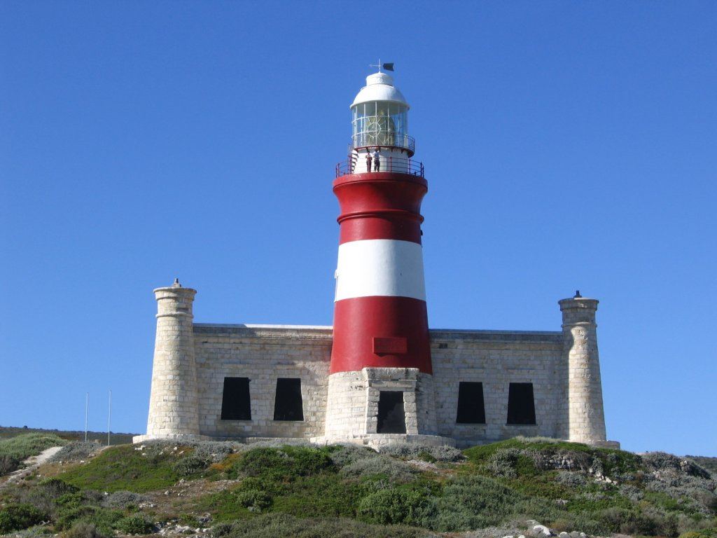
Hero image: Dewet, CC BY-SA 2.0, via Wikimedia Commons
Cape Agulhas is the southernmost point of the African continent and the place where, by international convention, the Atlantic and Indian Oceans meet. It is also low, flat, windswept and completely unlike the dramatic headland most people expect. That mismatch is the first thing to get straight, and the second is the difference between the cape and the village.
It lies at the bottom of the Cape Overberg, about two and a half hours from Cape Town and an hour and a half beyond Gansbaai on the Whale Coast route.
In this guide
- Cape Agulhas or L’Agulhas? The difference
- Where the two oceans meet, accurately
- The tip, the boardwalk and the marker
- Agulhas National Park
- The lighthouse
- Shipwrecks
- L’Agulhas, Struisbaai and the coast
- Weather, wind and the sea
- When to come
- How long you need
- Where to stay at Cape Agulhas
- Cape Agulhas and Cape Point: which is which
- Planning a Cape Agulhas visit around the weather
- Nearby, and what to do next
- Practical notes
- Official sources
Cape Agulhas or L’Agulhas? The difference
These are two different things and the names are used loosely.
- Cape Agulhas is the geographic cape itself — the actual southern tip of the continent, inside Agulhas National Park, marked by a stone cairn and a plaque. SANParks gives the official position of the tip as 34°49’58″S, 20°00’12″E.
- L’Agulhas is the small coastal settlement immediately next to it — where the accommodation, the shops, the lighthouse and most of the visitors actually are.
- Struisbaai is the larger village a few minutes east, with the long beach, the working fishing harbour and more services.
- Bredasdorp, about half an hour inland, is the district town where the supermarkets, fuel and the Shipwreck Museum are.
In practice you stay in L’Agulhas or Struisbaai, and you walk or drive the short distance to the cape.

Where the two oceans meet, accurately
SANParks, which manages the site, states plainly that the cairn at the tip marks the point where “the Atlantic and Indian oceans officially meet”. The operative word is officially. This is a boundary set by international hydrographic convention — a line drawn on charts along the meridian of Cape Agulhas so that ships, charts and maritime law all use the same definition. It is a legal and cartographic fact, and it is a real one.
What it is not is a physical feature you can see. There is no line in the water, no colour change, and no meeting of currents at your feet, whatever the photographs on social media suggest.
The physical picture is different and better. The South African government’s own description of the country’s geography sets it out: “The warm Mozambique-Agulhas Current skirts the east and south coasts as far as Cape Agulhas, while the cold Benguela Current flows northwards along the west coast.” The warm Agulhas Current runs down the east coast and turns back on itself south of here, shedding enormous eddies of warm salty water westwards into the Atlantic. The cold Benguela system runs up the west coast. Between them is a wide, mobile frontal zone that shifts with season and conditions, sometimes by hundreds of kilometres.
So: stand at the cairn, take the photograph, and know that you are standing on the agreed boundary of two oceans rather than watching them collide. The interesting thing here is the water temperature difference you can feel over a hundred-odd kilometres of coast, not a seam in the sea.
The tip, the boardwalk and the marker
The southernmost point sits inside Agulhas National Park and is reached by a short boardwalk from a car park, with a stone cairn and a plaque at the end. The walk is level and takes a few minutes. There is usually a queue for the photograph in season, and it is worth waiting.
Nearby, a second marker maps the outline of Africa in relief, which is a better photograph than the plaque for most people. The coast either side is a shelf of dark rock, tidal pools and fynbos, and walking along it away from the marker is where the place actually becomes memorable.
Agulhas National Park
The park protects the southernmost tip of the continent together with the surrounding coastal plain and interior — limestone fynbos, wetlands, a long low rocky coastline and the archaeology and maritime history that go with it. It is not a big-game park; it is a landscape and heritage park, and it rewards walking.
- Activities — birding, walks, fishing, whale watching in season, and the flower season in spring.
- Accommodation — SANParks runs chalets at Agulhas Rest Camp and the Bergplaas guest house inside the park.
- Fees — a conservation fee applies. SANParks reviews tariffs annually, so check the current schedule before you travel, and note that SANParks gates in the Western Cape are increasingly card-only.
- Wind — this is one of the windiest stretches of the South African coast. Take a windproof layer whatever the forecast.
The lighthouse
The Cape Agulhas Lighthouse stands at L’Agulhas in its distinctive red-and-white bands. SANParks describes it as the second oldest working lighthouse in southern Africa, built to help early navigators through what is one of the more dangerous pieces of water on the continent. It was built partly from stone quarried nearby, has seventy-one steps to the top, and houses a small museum on lighthouse history.
East of the lighthouse, ancient Khoisan fish traps are still visible in the intertidal rock — stone walls built to hold fish as the tide dropped. They are among the oldest human structures on this coast and they are easy to miss if nobody tells you they are there.
Shipwrecks
The coastline here is littered with wrecks, and the ones SANParks names include the Zoetendal, the Birkenhead and the Arniston. The wreck most visitors actually see is the Meisho Maru 38, a Japanese trawler that went aground west of the tip in 1982 and whose bow section still stands out of the surf. A short walk from the road gets you to a viewpoint over it.
For the wider story, the Shipwreck Museum at Bredasdorp holds material recovered from wrecks along the Agulhas coast, and it is the best half-hour in the district on a wet day.
L’Agulhas, Struisbaai and the coast
L’Agulhas is small, low and built for the wind. It has the lighthouse, a handful of places to eat, and the closest accommodation to the tip.
Struisbaai, a few minutes east, has the long white beach that gives this coast its holiday reputation, a working fishing harbour where boats come in and are unloaded, and more shops. Swimming is realistic here in a way it is not on the exposed rock at the cape, though there is no substitute for local advice on currents and no lifeguard cover outside the peak season.
Between and beyond the two, the coast is low rock, tidal pools and fynbos, with walking in every direction and very few people on it outside December.
Weather, wind and the sea
The wind here is not incidental; it is the defining condition. This coast is exposed from almost every direction and a strong blow can make the boardwalk to the tip genuinely uncomfortable. Summer brings the south-easter; winter brings north-westerly fronts and rain. Either way, bring a windproof layer and expect the temperature to be several degrees lower than the forecast suggests.
The sea is dangerous and should be treated as such. Rock fishing along this coast has a long history of people being swept off, and the swell can rise fast. Do not turn your back on the water on the rocks, and do not swim off the cape itself.
When to come
- Spring, September to November — the best window. Fynbos flowering, southern right whales still along the coast, and the wind slightly less relentless.
- Summer, December to February — hot, very windy, and full of South African holidaymakers. Struisbaai is at its busiest.
- Autumn, March to May — quiet, mild and often the clearest weather of the year.
- Winter, June to August — cold, wet, dramatic and almost empty. Whales begin arriving from June.
How long you need
The tip itself takes an hour, including the walk and the photograph. A proper visit — the tip, the lighthouse, the Meisho Maru, a coastal walk and Struisbaai harbour — is a comfortable full day. Most people who come this far stay a night, and that is the right call: it is a long drive from anywhere and the light at either end of the day is the best of it.
Where to stay at Cape Agulhas
Check availability at Cape Agulhas
Most visitors base themselves in L’Agulhas, Struisbaai or Suiderstrand rather than at the tip itself. Options run from self-catering houses to small guesthouses, and the villages fill up over South African school holidays.
See Cape Agulhas stays on Booking.comAffiliate link. We may earn a commission if you book through it, at no additional cost to you. See our affiliate disclosure.
Almost all accommodation is in L’Agulhas and Struisbaai, plus the SANParks chalets and guest house inside Agulhas National Park. Self-catering dominates; this is a South African holiday coast rather than a hotel one, and December and Easter book out well in advance.
L’Agulhas puts you closest to the tip and the lighthouse. Struisbaai gives you the beach, the harbour and marginally more choice for dinner. Both are quiet out of season, and neither has much in the way of evening life — plan on eating early or cooking.
Cape Agulhas and Cape Point: which is which
Many visitors arrive here having already stood at Cape Point, and a surprising number assume the two are the same landmark. They are not, and the difference matters. Cape Point sits at the tip of the Cape Peninsula, well to the north-west, and it is the more theatrical of the pair — high sandstone cliffs, a funicular railway, a large and busy visitor operation. Cape Agulhas is the quieter one, and the geographically significant one: this is the true southern extremity of the African continent, and the line at which the Atlantic and Indian Oceans are formally separated.
The visual contrast is what catches people out. Cape Point rises; Cape Agulhas lies flat. There is no cliff-top viewpoint here and no cable car — the southern tip is a low, rocky, wind-scoured shelf with a boardwalk running out across it and a stone marker at the end. Travellers who arrive expecting a Cape Point-style spectacle sometimes leave underwhelmed. Travellers who understand what they are standing on almost never do.
If you are working out how to fit both into one trip, treat them as separate journeys rather than a single day out. They sit in different parts of the Western Cape and belong to different routes: Cape Point pairs naturally with the peninsula, while Cape Agulhas belongs with the Overberg and the whale coast.
Planning a Cape Agulhas visit around the weather
Cape Agulhas is exposed on every side, and the weather shapes a visit here more than the calendar does. Wind is the constant. The same conditions that made this coastline so dangerous to sailing ships still make the boardwalk cold and the sea heavy on a poor day, so bring a genuine windproof layer whatever the month, and expect the light to change quickly while you are out on the rocks.
Because the walk out to the marker and back is short, Cape Agulhas rewards a flexible plan rather than a fixed arrival time. If the wind is up when you get here, the lighthouse and the villages along the shore give you somewhere to wait; if the weather clears, the tip is only a few minutes away and you can turn straight back to it. Building a tight schedule around one appointed moment at the southern tip is the approach that most often disappoints.
Nearby, and what to do next
- Gansbaai — an hour and a half north-west, for the harbour, De Kelders and marine trips.
- Hermanus — a little over two hours north-west, the anchor of the Whale Coast.
- Stanford — a quiet river village on the same route.
- Arniston (Waenhuiskrans) — half an hour east, a whitewashed fishing village with a sea cave and a declared heritage settlement.
- Bredasdorp — half an hour inland, for the Shipwreck Museum, fuel and supplies.
- De Hoop Nature Reserve — the CapeNature reserve further east, with the best land-based whale watching on this coast. Check access and permits with CapeNature.
- Cape Overberg overview — how the region fits together.
De Hoop Nature Reserve lies east along the coast, roughly two hours by road via Bredasdorp, and Swellendam is about an hour and a half north on the N2 — the natural next stop if you are heading for the Garden Route.
Practical notes
- Fuel — fill up at Bredasdorp or Struisbaai. Do not set out on the back roads to Elim on a low tank.
- Card payments — SANParks gates in the Western Cape are card-only. Carry a card that works.
- Gravel — several of the good back roads here are gravel and fine in an ordinary car, but slow down and watch for washboard.
- Fynbos and heritage — do not pick flowers, do not disturb the fish traps, and do not remove anything from a wreck site. Both are protected.
- Whales — June to late November along this coast, and best from the cliffs rather than from a boat here.
Official sources
- SANParks — Agulhas National Park — the southernmost tip, the official coordinates, the lighthouse, accommodation and current fees.
- South African Government — Geography and climate — the official description of the Agulhas and Benguela current systems.
- Cape Agulhas Tourism — local destination information for L’Agulhas, Struisbaai, Bredasdorp and Arniston.
- CapeNature — De Hoop and the surrounding reserves, permits and alerts.
- Heritage Western Cape — heritage protection covering the fish traps, wrecks and declared settlements.
Where to stay, and what to book
Our Cape Agulhas accommodation page carries a short orientation to the area and a live availability map.